E Mail : info@mibtravelsandtours.com

Hot Line  : +95-9-5143537, +95-9-402626510

Mrauk U


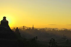
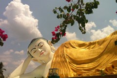
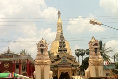
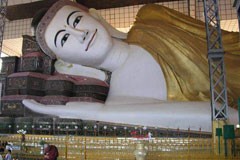
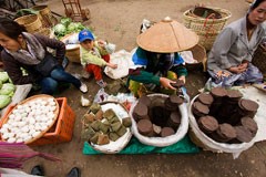
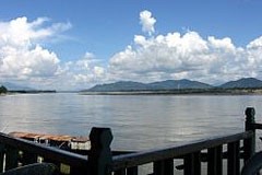
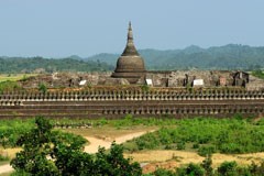
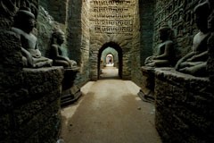
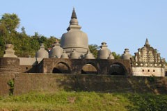
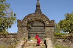
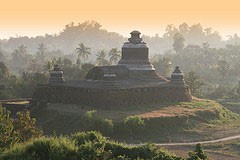
Mrauk U: Stone carved pagodas from 14th to 17th century can be seen only in Mrauk U. It was located at the western side of Myanmar. From Yangon fly to Sittwe,the capital of Rakhine State,then take a private boat to Mrauk U. The boat trip will take about 5 Hours depend on the current along the Kaladan River. Mrauk U was formerly the capital of Mrauk U dynastry and before Sittwe was the capital Rakhine State.Most of the Pagodas in and around Mrauk U were from the 14th to 17th Century,the flourish time from Mrauk U dynastry. The Shittaung Temple,means 80,000 buddha images, Htokekanthein Temple, the ordination Hall, Andaw Thein temple, the pagoda with tooth relice, Koethaung Temples, it likes bororbordor from Indonesia are the famous sightseeings in Mrauk U. 

Geography

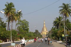
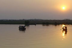
Mrauk U lies roughly 11 km east of the Kaladan River on the banks of its minor tributaries. The town is located on a small outcrop of the Rakhine Yoma on the eastern side of the Kaladan's alluvial plain. Thus, the surrounding countryside is hilly yet also contains a great deal of marshes, mangroves and lakes.

Climate

Mrauk U, like much of Rakhine State, is situated in a coastal tropical monsoon rainforest climate region. The town receives over 1200mm of rain a year from the Southwestern Monsoon, making it one of the wettest regions in Myanmar. The Monsoon season usually begins in late May and ends by mid October.

Although located in a tropical region, Mrauk U enjoys lower temperatures when the Northeastern Monsoon falls. From mid October to mid March during the Cool Season, temperatures can drop to 13°C. This season coincides with the tourist season for Myanmar.


Religious Centre

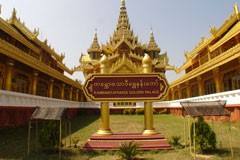
As Mrauk U and her kingdom prospered, the kings, ministers and peasants built many pagodas and temples around the town to reflect their faith. Thus, Mrauk U houses a rich collection of temples and pagodas second only to the Central Burmese town of Bagan, in Myanmar. Most of Mrauk U's temples were constructed of hewn stone bricks, unlike the mud and clay bricks of Bagan.

The most notable temples in Mrauk U are the Shite-thaung Temple (Temple of 80,000 Images or Temple of Victory), Htukkanthein Temple (Htukkan Ordination Hall), the Koe-thaung Temple (Temple of 90,000 Images) and the Five Mahn pagodas.
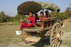


Tourism

Today, Mrauk U is a major archaeological and tourist destination. The main attractions are the temples and ruins around the town. The remains of the main palace roughly form the centre of the town. The most popular mode for tourists to travel to Mrauk U is to take a domestic flight from Yangon to Sittwe and board a boat from Sittwe against the Kaladan River. The hotels in Mrauk U also arrange private boat services to and fro Sittwe.

Mrauk U houses a growing tourist industry, as it has only recently become a reachable tourist destination.

Bago


Bago: Thai and Myanmar correlation in 16th century can be seen here in Pegu. Pegu is about 1.5 hours drive from Yangon. The capital of King Bayintnaung in 16th Century was now small town along the way from Yangon to Kyaikhtiyo Pagoda (Golden Rock). The Shwemawdaw Pagoda is the landmark of this region and can be seen from far away.

History

According to legend, two Mon princesses from Thaton founded Bago in 573 AD. It was written in the chronicles that eight years after enlightenment, Lord Buddha along with his disciples flew around the Southeast Asian countries. On his return journey while crossing the Gulf of Martaban, which happened to be at low tide, he saw two golden sheldrakes sitting, female on top of male, on a peak of land protruding out of the sea just enough for a bird's perch. Viewing this strange phenomenon, he predicted to his disciples that one day a country where his doctrine would thrive would come into existence in this vast sea area. That part of the sea, when it was silted up and ready for habitation approximately 1500 years after the prediction, was colonized by Mons from the Thaton Kingdom. Thus, the Mons became the first rulers of this country known in history as Hongsawatoi ; from Pali Hamsavati. Other spelling variations on the name include Hanthawaddy, Hanthawady, Hanthawadi and Handawaddy. In Thai, it is called Hongsawadi.

Bago was rebuilt by King Bodawpaya , but by then the river had shifted course, cutting the city off from the sea. It never regained its previous importance. After the Second Anglo-Burmese War, the British annexed Bago in 1852. In 1862, the province of British Burma was formed, and the capital moved to Yangon. The name Bago is spelt peh kou literally. The substantial differences between the colloquial and literary pronunciations, as with Burmese words, was a reason of the British corruption "Pegu".


In 1911, Hanthawaddy was described as a district in the Bago (or Pegu) division of Lower Burma. It lay in the home district of Yangon, from which the town was detached to make a separate district in 1880. It had an area of 3,023 square miles (7,830 km2), with a population of 48,411 in 1901, showing an increase of 22% in the past decade. Hanthawaddy and Henzada were the two most densely populated districts in the province.

Hanthawaddy, as it was constituted in 1911, consisted of a vast plain stretching up from the sea between the to (or China Bakir) mouth of the Ayeyarwaddy River and the Pegu Yomas. Except the tract of land lying between the Pegu Yomas on the east and the Hlaing river, the country was intersected by numerous tidal creeks; many of which were navigable by large boats and some by steamers. The headquarters of the district was in Rangoon, which was also the sub-divisional headquarters. The second sub-division had its headquarters at Insein, where there were large railway works. Cultivation was almost wholly confined to rice, but there were many vegetable and fruit gardens.

Today, Hanthawaddy may be considered a district of the city of Bago.

Kyaing Tong


Kengtung Township (Burmese: က်ဳိင္းတုံ; also spelled Kyaingtong, Kengtong ) is a township of Kengtung District in the Shan State of Burma. The principal town is Kengtung. It lies almost entirely east of the Salween River and its area is over 12,000 square miles (31,000 km2). It is bounded on the north by the states of Mang Lon, Mong Lem and Keng Hung (Hsip Hsawng Pannh); east by the Mekong River, south by the Siamese Shan States, and west in a general way by the Salween River, though it overlaps it in some places. The state is known to the Chinese as Mhng Khng, and was frequently called by the Burmese the 32 cities of the Gn (HkOn). The classical name of the state is Khemarata or Khemarata Tungkapuri.

Geography and Climate

Kengtung is the largest, most mountainous, most easterly, and culturally the farthest from the Burmese, of all the Shan States. Geography makes approach to it from the rest of Burma difficult for it lies not only beyond the Salween across which no bridge has been built and whose eastern tributaries have cut no easy routes through the serried north-south ranges, but nearer again to the Mekong than to the Salween.

About 63% of the area lies in the basin of the Mekong River and 37% in the Salween drainage area. The watershed is a high and generally continuous range. Some of its peaks rise to over 7,000 ft (2,100 m)., and the elevation is nowhere much below 5,000 ft (1,500 m). Parallel to this successive hill ranges run north and south with mountainous country predominating.

Kengtung, the capital, is situated towards the southern end of a valley about 12 miles (19 km) long and with an average breadth of 7 miles (11 km). The town is surrounded by a brick wall and moat about 5 miles (8.0 km) round. Only the central and northern portions are much built over. In the dry season crowds attend the market held according to Shan custom every five days, and numerous caravans come from China. The plain in which the capital stands has an altitude of 3,000 ft (910 m).

The rainfall probably averages between 50 and 60 inches (1.5 m) for the year. The temperature seems to rise to nearly 100 F. during the hot weather, falling 30 or more during the night. In the cold weather a temperature of 40 F. or a few degrees more or less appears to be the lowest experienced.

Ngwe Saung Beach


Ngwesaung (Burmese: ေငြေဆာင္, pronounced [ŋwè zàuɴ]) is a beach resort located 48 km west of Pathein, Ayeyarwaddy Division, Myanmar. The beach is 5 hours' drive away from the principal city of Yangon, and an airport is in the works. Opened in March 2000, Ngwe Saung is newer than nearby and more popular Chaungtha Beach, and is designed to attract people with larger holiday budgets.

An unspoilt 15-km stretch of silvery sand and modern amenities have made Ngwesaung a popular destination for less budget conscious tourists from Lower Myanmar. Still Ngwesaung has much to develop. Its choices for nightlife activities remain paltry, even by local standards. Chaungtha and Ngapali beaches have greater choices of nighttime activities. At this point, a nearby elephant training camp is a main daytime attraction at Ngwesaung.

Myitkyina


Myitkyina (Burmese: ျမစ္ၾကီးနား ;) is the capital city of Kachin State in Myanmar (Burma), located 919 miles from Yangon, or 487 miles from Mandalay. In Burmese it means "near the big river", and in fact "Myitkyina" lies on the west bank of the Ayeyarwady River, just below 25 miles from Myit-son (Burmese for confluence) of its two headstreams (the Mali and N'mai rivers).It is the northernmost river port and railways terminus in Myanmar.

History
Myitkyina has been a important trading town between China and Burma since ancient times. American Baptist missionary George J. Geis and his wife arrived in Myitkyina in the late 1890s and in 1900 requested permission to build a misison there.

In August 1944 during World War II, Myitkyina fell to the Allied forces under General Joseph Stilwell after a prolonged siege and heavy fighting between Nationalist Chinese divisions, the Chindits, and Merrill's Marauders of the Northern Combat Area Command and the besieged elements of the 33rd Imperial Japanese Army under General Masaki Honda. The town was strategically important not only because of its rail and water links to the rest of Burma, but also because it was on the planned route of the Ledo Road.

As the capital of the state, it has government offices, and a greater population than other cities in the state. The city has a population of approximately 150,000, with a mix of Kachin, Shan, Bamar peoples and some Chinese and Indians. Fragrant rice produced near Myitkyina, called khat cho, is considered the best in Myanmar.

The Kachin language is the common language among the Kachin, but Burmese is the national language and everyone can speak Burmese. It has two big markets. The city is home to Myitkyina University, a teachers college, a nurses training school, and a computer college, and various Christian theological seminaries and colleges affiliated with several seminaries in the U.S. and Asia, notably Kachin Theological College-Nawng Nan.

Major religions are Theravada Buddhism and Baptist Christianity, but other religions such as animism, Hinduism and Islam are also practised. Foreigners are now free to visit Myitkyina without prior government permission.

Puta O

Putao: Snow-capped mountain range and forests in this region offering opportunities for Ecotourism in Myanmar. Myanmar’s Kachin State in the Eastern Himalayas remains one of the least visited wilderness areas on earth.It recently become possible to visit many areas of this little known destination.Putao, is the starting point for treks and offers exclusive trekking programs into this tribal land of dense forests and the snow capped mountain. Pong-kan-ra-ze, 61 miles away from Putao is one of the most trekable snow-capped mountains to conquer. Throughout the road to Pong-kan-ra-zi, one can see Lisu, Rawang, Khanti-Shan and Jingphaw ethnic tribes. Myitkyina is the capital of Kachin state and means “near the river”. The confluence of Maykha and Malikha rivers near Myitkyina is the starting point of the meaningful Ayeyarwaddy River. Kachin Manaw Festival is the highlight in this region and which helds every years in the month of January.

Khakaborazi Mountain

Khakaborazi Mountain and other snow-capped mountains are visible from Putao. Putao attracts also enthusiasts, hiking to Khakaborazi base camp, located close to Tahaundam.

Hkamti Long

Hkamti Long (also Khamti Long) is the former name of the area around the city of Putao in Myanmar (formerly known as Burma) settled by the Hkamti Shan people of the country. The name means "Great Place of Gold" in the Hkamti Shan language . Nowadays, there are Rawang and Lisu nationalities which are already regarded as Kachin nationalities. The seven-day-trek to West-Putao's mountain region, in which explorers found that there are Hta Lone (Hta Rone) ethnic whose height are lower than four feet. The population of this ethnic minority is so few nowadys that they are facing the threat of being extinct. The area covered by Hkamti Long may have included parts of what is now Kachin State (where Putao is located) as well as that of Shan State.

Climate

The climate of Putao is a monsoon-influenced humid subtropical climate (Köppen climate classification Cwa) with extreme amount of precipitation throughout the monsoon season.
Average temperature in January is 13.1°C, August is the hottest month with 25.9°C.

Page 2 of 2

Style Selector

Layout Style

Background Image