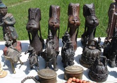
E Mail : info@mibtravelsandtours.com

Hot Line  : +95-9-5143537, +95-9-402626510

Ngapali Beach

Your physical and mental recovery and for memorable leisure, please spent your time at Ngapali beach. The Ngapali beach was the best in Myanmar, where you can enjoy 3S (sea, sand and sun). The private Bungalows, beautiful beach with white sand under sun shine can bring your enjoyable moments in Myanmar.
The beach stretches for 3 km (2 mi) and overlooks the Indian Ocean. The name "Ngapali", has no meaning in Burmese, but comes from the Italian "Napoli" (the city of Naples).
Ngapali Beach has been promoted as a major tourist destination in Myanmar. Several resorts and hotels are located in Ngapali, usually of the high end - such as Bayview Ngapali, Amata Resort, Amazing Ngapali and also the government owned Anawa. Ngapali used to have private bungalos, but these were torn down in the late 1990s to make way for the development of hotels. The hotels and small tourism industry helps to provide income for the villages around Ngapali and also Thandwe. There is also a golf course nearby.
The beach is served by Thandwe Airport. All of Myanmar's internal airlines, Myanma Airways, Air Mandalay, Yangon Airways and Air Bagan have frequent flights to Thandwe from most of their destinations. Ngapali's isolation means that few people are able to afford the airfare, thus making it more popular amongst tourists as an unspoilt and private beach.

Naypyidaw


The new capital and seat of government was famous in these years. About 300 km north of Yangon, the former capital was announced on Armed Forces Day in March 2006. The official explanation for moving the capital was that Yangon had become too congested and crowded with little room for future expansion of government offices. It takes about nine hours by train from Yangon to Naypyidaw. The regular flights from domestic airlines fly to Nay Pyi Taw Airport, located 10 miles southeast of the city. A new highway from Yangon to Nay Pyi Taw has been opened recently and now the travelling time from Yangon to Nay Pyi Taw is only about 4 hours drive. City Hall is one of the prominent Land Marks of Nay Pyi Taw, in which Nay Pyi Taw Development Committee establishes its headquarters.Uppatasanti Pagoda, the replica of Shwedagon Pagoda from Yangon is the main pagoda from this capital. Water fountain Garden is the best picnic place for the people. The gem museum Naypyidaw is fully covered with the jade stones.

Geography
Naypyidaw is located between the Bago Yoma and Shan Yoma mountain ranges. The city covers an area of 7,054.37 square km and has a population of 924,608, according to official figures. Chaungmagyi Dam is located a few kilometers to the north of Naypyidaw, while Ngalaik Dam is a few kilometers to the south. The Yezin Dam is further away, to the northeast.

Recreation
Ngalaik Lake Gardens is a small water park situated along the Ngalaik Dam, near Kyweshin Village on Ngalaik Lake (approximately seven miles from Naypyidaw). Opened in 2008, facilities at the Ngalaik Lake Gardens include water slides, natural resorts, lodging and a beach. The gardens are open to the public during Thingyan holidays.

Naypyidaw Water Fountain Garden
Also opened in 2008, the 200-acre (0.81 km2) National Herbal Park has exhibits of plants having medicinal applications from all of the major regions of Burma. There are thousands of plants at the park, representing hundreds of different species.
The Naypyidaw Zoological Gardens opened in 2008 with some 420 animals and a climate-controlled penguin house. It is the largest zoo in Burma. The Naypyidaw Safari Park officially opened on 12 February 2011.
Naypyidaw also has two golf courses (Nay Pyi Taw City Golf Course and Yaypyar Golf Course), and a gem museum.

Uppatasanti Pagoda
Similar in size and shape to the Shwedagon Pagoda in Yangon, Uppatasanti Pagoda was completed in 2009. This new pagoda is named the Uppatasanti or "Peace Pagoda". The stake-driving ceremony for the pagoda was held on 12 November 2006.The invitation card for the ceremony opened with a phrase "Rajahtani Naypyidaw (the royal capital where the king resides)". The pagoda is just 30 cm shorter than the Shwedagon Pagoda. Uppatasanti translates roughly to "Protection against Calamity". It is the name of a sūtra prepared by a monk in the early 16th century. It is to be recited in time of crisis, especially in the face of foreign invasion.

Mandalay


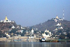
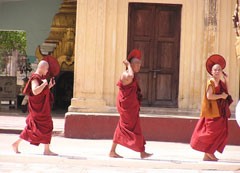
Mandalay: center for the culture of Myanmar and last capital of myanmar kingdom was Mandalay. About 300 Monasteries in and round the city means Mandalay was also the center for Buddhism. King Mindon founded Mandalay at the foot of Mandalay Hill according to the cosmology. The golden palace and moat can be see till nowadays but some are rebuilt. The Kuthodaw,”the largest book of the world”, was the pagoda complex, in which 729 marble slabs are hoisted. Mingun, the temporary palace of King from the western side of Ayeyarwaddy River was famous for the unfinished Pagoda and 90 tons weight Bell. In Amarapura, the 1.2 km long wooden bridge.

Etymology

The city gets its name from the nearby Mandalay Hill. The name is likely a derivative of a Pali word although the exact word of origin remains unclear. The root word has been speculated as: "Mandala" (meaning, circular plains), "Mandare" (believed to mean "auspicious land"), or "Mandara" (a mountain from Hindu mythology).

When it was founded in 1857, the royal city was officially named Yadanabon , the Burmese version of its Pali name *Ratanapura* which means "The City of Gems". It was also called Lay Kyun Aung Myei; Victorious Land over the Four Islands and the royal palace, Mya Nan San Kyaw ; Famed Royal Emerald Palace.

Early history

Like most former (and present) capitals of Burma, Mandalay was founded on the wishes of the ruler of the day. On 13 February 1857, King Mindon founded a new royal capital at the foot of Mandalay Hill , ostensibly to fullfill a prophecy on the founding of a metropolis of Buddhism in that exact place on the occasion of the 2,400th jubilee of Buddhism.

Geography

Mandalay is located in the central dry zone of Burma by the Irrawaddy river at 21.98° North, 96.08° East, 64 metres (210 feet) above sea level. Its standard time zone is UTC/GMT +6:30 hours.


Around the city

Mandalay Hill : The hill has for long been a holy mount. Legend has it that the Buddha, on his visit, had prophesied that a great city would be founded at its foot. Mandalay Hill, 230 metres in elevation, commands a magnificent view of the city and surrounding countryside. The construction of a motor road to reach the hill-top has already been finished.
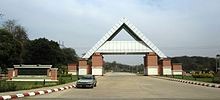
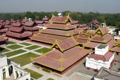
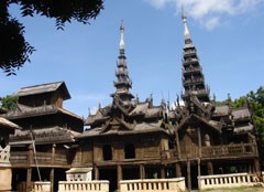
Mandalay Palace : The whole magnificent palace complex was destroyed by a fire during World War II. However, the finely built palace walls, the city gates with their crowning wooden pavilions and the surrounding moat still represent an impressive scene of the Mandalay Palace, "Mya-nan-san-kyaw Shwenandaw", which has been rebuilt using forced labour. A model of the Mandalay Palace, Nanmyint-saung and Cultural Museum are located inside the Palace grounds.
Shwenandaw Monastery : Famous for its intricate wood-carvings, this monastery is a fragile reminder of the old Mandalay Palace. Actually, it was a part of the old palace later moved to its current site by King Thibaw in 1880.
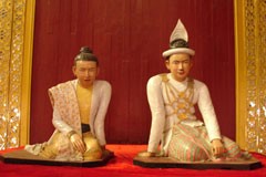
Maha Muni Pagoda : The Image is said to have been cast in the life-time of the Gautama Buddha and that the Buddha embraced it 7 times thereby bringing it to life. Consequently, devout Buddhists hold it to be alive and refer to it as the Maha Muni Sacred Living Image. Revered as the holiest pagoda in Mandalay, It was built by King Bodawpaya in 1784. The image in a sitting posture is 12 feet and 7 inches (3.8 m) high. As the image was brought from Rakhine State it was also called the Great Rakhine Buddha. The early morning ritual of washing the Face of Buddha Image draws a large crowd of devotees everyday. The Great Image is also considered as the greatest, next to the Shwedagon Pagoda , in Burma. A visit to Mandalay is incomplete without a visit to Maha Muni Pagoda.
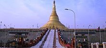
Kuthodaw Pagoda (The World's Biggest Book): Built by King Mindon in 1857, this pagoda modeled on the Shwezigon Pagoda at Nyaung U, is surrounded by 729 upright stone slabs on which are inscribed the entire Buddhist Scriptures as edited and approved by the Fifth Buddhist Synod . It is popularly known as "the World Biggest Book".
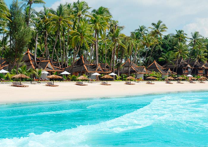
Inle Lake


Inle Lake: the unique leg-rowers and floating gardens on the lake between the two mountain ranges, this picturesque view was only from Inle Lake.The 11 km long lake lies near Nyaungshwe, a small harbor town ,about 1 hour drive from the small airport Heho in Shan state. Long tailed boats are the only transport material in Inle lake.Phaungdawoo Pagoda is the main Pagoda and while the pagoda ceremony in october, there is crowded on the Lake. The Indein pagoda complex with 1054 pagodas in ruins dating back to 14th century. Boat ride along the Indein creek from the Phaungdawoo Pagoda to Indein is the wonderful trip.The trekkings to the ethnic villages around Kalaw and Pindaya were the chance to contact with the local people.Pindaya Cave is the 150 meters long lime stone cave with about 80,000 Buddha images inside. The orange and rice plantations on the red soil gives you the scenic view from this region.

People and culture
The people of Inle Lake (called Intha), some 70,000 of them, live in four cities bordering the lake, in numerous small villages along the lake's shores, and on the lake itself. The entire lake area is in Nyaung Shwe township. The population consists predominantly of Intha, with a mix of other Shan, Taungyo, Pa-O (Taungthu), Danu, Kayah, Danaw and Bamar ethnicities. Most are devout Buddhists, and live in simple houses of wood and woven bamboo on stilts; they are largely self-sufficient farmers.

Most transportation on the lake is traditionally by small boats, or by somewhat larger boats fitted with outboard motors. Local fishermen are known for practicing a distinctive rowing style which involves standing at the stern on one leg and wrapping the other leg around the oar. This unique style evolved for the reason that the lake is covered by reeds and floating plants making it difficult to see above them while sitting. Standing provides the rower with a view beyond the reeds. However, the leg rowing style is only practiced by the men. Women row in the customary style, using the oar with their hands, sitting cross legged at the stern.

Environmental concerns
Inle Lake is suffering from the environmental effects of increased population and rapid growth in both agriculture and tourism. During the 65-year period from 1935 to 2000, the net open water area of Inle Lake decreased from 69.10 km² to 46.69 km², a loss of 32.4%.
Tourism
The best time of the year to visit is during September and October. The ceremonial Phaung Daw U Festival, which lasts for almost three weeks, is closely followed by the Thadingyut festival of lights. Inthas and Shan turn out in their best clothes in great numbers to celebrate the Buddhist Lent. Traditional boat racing, with dozens of leg-rowers in Shan dress in a team on each boat, is a famous event during the Phaung Daw U Festival.

Cuisine
Inle cuisine is different from Shan cuisine, as it incorporates local natural produce. The most well-known Inle dish would be the Htamin jin - a rice, tomato and potato or fish salad kneaded into round balls dressed and garnished with crisp fried onion in oil, tamarind sauce, coriander and spring onions often with garlic, Chinese chives roots (ju myit), fried whole dried chili, grilled dried fermented beancakes (pè bou) and fried dried topu (topu jauk kyaw) on the side.

Bagan


Bagan: is home to the larges area of Buddhist temples,pagodas,stupas and ruins in the world with many dating from the 11th and 13th centuries.Bagan is not only the main tourist attraction in Myanmar also one of the richest archaeological sites in South-east Asia.Dotted with thousands of temples and pagodas,some dating back hundreds of years and some are rebuilt after the devastation of large earthquake in 1975. One cannot forget Sunrise and Sunset of panoramic view from Bagan with thousands of Pagodas. Riding with Horse-carts between the Pagodas and sunset from the boat on the Ayeyarwaddy river are the memorable moments you can do during your trips in Bagan.
Cause Bagan lies in the dry zone of middle Myanmar, is accessible in every season,whether there is rainy season. The villages in and around Bagans dating back to the ancient style of livings. lacquer ware from Bagan has the most cultural distinction and traditional value to all Myanmar. Horse-carts and lacquerware workshops remain as the main income sources for the local people in Bagan.Popa Mountain in this region,about 1500 meters high, is famous as the Oasis in dry zone and the resident for the Nats(Spirits). The Yokesone Monastery at Salay reflects the picturesque wood carving technique from ancient time. One can enjoy the charming of Ayeyarwaddy River, along the Boat trip from Bagan to Pakokku.
Shwezigon Pagoda: the prototype for all the stupas in Myanmar.It was founded by King Anawratha in 11th century after the conquer of Mon Kingdom from lower Myanmar. The sandstones, which used to built this Pagoda were got from the 11 km far Tuyin taung.Now was the Shwezigon Pagoda one of the main attractions from Bagan.The events of Pagoda Festival during November was also one of the highlight in Bagan.

Ananda Temple: the finest temple among all the temples in Bagan.It was built by the King Kyansittha in 11th Century in the mixture of Myanmar and Mon architecture. Ananda Temple is like the museum of all myanmar arts and crafts.
Architectural styles
The religious buildings of Bagan are often reminiscent of popular architectural styles in the period of their constructions. The most common types are:

  • Stupa with a relic-shaped dome
  • Stupa with tomb-shaped dome
  • Sinhalese-styled stupa
  • North Indian model
  • Central Indian model
  • South Indian model
  • Mon model


History
The ruins of Bagan cover an area of 16 square miles (41 km2). The majority of its buildings were built in the 11th century to 13th century, during the time Bagan was the capital of the First Burmese Empire. It was not until King Pyinbya moved the capital to Bagan in AD 874 that it became a major city. However, in Burmese tradition, the capital shifted with each reign, and thus Bagan was once again abandoned until the reign of Anawrahta. In 1057, King Anawrahta conquered the Mon capital of Thaton, and brought back the Tripitaka Pali scriptures, Buddhist monks and craftsmen and all of these were made good use of in order to transform Bagan into a religious and cultural centre. With the help of a monk from Lower Burma, Anawrahta made Theravada Buddhism a kind of state religion, and the king also established contacts with Sri Lanka. In the 12th and 13th centuries, Bagan became a truly cosmopolitan centre of Buddhist studies, attracting monks and students from as far as India, Sri Lanka as well as the Thai and Khmer kingdoms. Among many other works, Aggavaṃsa's influential Saddanīti, a grammar of the language of the Tipiṭaka, would be completed there in 1154. In 1287, the kingdom fell to the Mongols, after refusing to pay tribute to Kublai Khan. Abandoned by the Burmese king and perhaps sacked by the Mongols, the city declined as a political centre, but continued to flourish as a place of Buddhist scholarship.

After the earthquake in 1975, there are only 2,217 pagodas left in Bagan, in contrast to more than 5,000 during height of the political centre. Thus in order to preserve the original pagodas, only horse-driven carriage are allowed to travel among the pagodas.


 Cultural sites

  • Ananda Temple, c.1090, built by Kyanzittha
  • Bupaya Pagoda, c.850, demolished by the 1975 earthquake and completely rebuilt
  • Dhammayangyi Temple, c.1165, the biggest temple in Bagan, built by Alaungsithu but never finished
  • Dhammayazika Pagoda, 1196–98, built by Narapatisithu (Sithu II)
  • Gawdawpalin Temple, started by Narapatisithu and finished by Nandaungmya, the superstructure destroyed by the 1975 quake and rebuilt
  • Htilominlo Temple, 1218, built by Htilominlo
  • Lawkananda Pagoda, built by Anawrahta
  • Mahabodhi Temple, Bagan, c. 1218, a smaller replica of the temple in Bodh Gaya, India
  • Manuha Temple, built by the captive Mon king Manuha
  • Mingalazedi Pagoda, 1268–74, built by Narathihapate
  • Myazedi inscription, c. 1113, described as the "Rosetta Stone of Burma" with inscriptions in four languages: Pyu, Mon, Old Burmese and Pali, dedicated to Gubyaukgyi Temple by Prince Rajakumar, son of Kyanzittha
  • Nanpaya Temple, c.1060-70, Mon style, believed to be either Manuha's old residence or built on the site
  • Nathlaung Kyaung Temple, mid 11th.C., Hindu deities "confined" to this temple
  • Payathonzu Temple, probably around 1200
  • Sein-nyet Ama & Nyima (temple and pagoda, 13th century)
  • Shwegugyi Temple, 1131, built by Alaungsithu and where he died
  • Shwesandaw Pagoda, c.1070, built by Anawrahta
  • Shwezigon Pagoda, 1102, built by Anawrahta, finished by Kyanzittha
  • Sulamani Temple, 1183, built by Narapatisithu
  • Tan-chi-daung Paya, on the west bank, built by Anawrahta
  • Tharabha Gate, c.850, built by King Pyinbya
  • Thatbyinnyu Temple, the tallest temple at 200 feet (61 m), 12th century, built by Alaungsithu
  • Tu-ywin-daung Paya, on the eastern boundary of Bagan, built by Anawrahta
Kyaikhtiyo Pagoda


Kyaiktiyo Pagoda (Burmese: က်ဳိက္ထီးရိုး ဘုရား ;also known as Golden Rock) is a well-known Buddhist pilgrimage site in Mon State, Myanmar. It is a small pagoda (7.3 metres (24 ft)) built on the top of a granite boulder covered with gold leaves pasted on by devotees. According to legend, the Golden Rock itself is precariously perched on a strand of the Buddha's hair. The rock seems to defy gravity, as it perpetually appears to be on the verge of rolling down the hill. The rock and the pagoda are at the top of Mt. Kyaiktiyo. It is the third most important Buddhist pilgrimage site in Burma after the Shwedagon Pagoda and the Mahamuni Pagoda. A glimpse of the "gravity defying" Golden Rock is believed to be enough of an inspiration for any person to turn to Buddhism.

Geography

The pagoda is located near Kyaikto in Mon State in the northern part of the Tenasserim coast. The Golden Rock is situated at an elevation of 1,100 metres (3,600 ft) above mean sea level, on top of the Kyaiktiyo hill (also known as Kelasa hills or Eastern Yoma mountains); it is on the Paung-laung ridge of the Eastern Yoma mountains. It is at a distance of 210 kilometres (130 mi) from Yangon. The Kinpun village 16 km (10 mi) is at the base of Mt. Kyaiktiyo. It is the closest to the Kyaiktiyo Pagoda. From Kyaiktiyo, the foot trail or road starts for the Golden rock. On this approach, there are numerous granite boulders on the mountain, perched in precarious condition. Near the top of the mountain, there are two large lions guarding the entrance to Kyaiktiyo Pagoda.
From this location, known as Yatetaung (the last point for vehicular traffic), pilgrims and visitors have to climb to the Golden Rock barefoot, after leaving their footwear behind, as per Burmese custom. The paved mountain track, built in 1999, from the bus terminal at Yatetaung, is along a dusty section with kiosks on both sides and the climb of 1.2 km up to the Golden Rock is stiff and takes about one hour to reach.From the base camp at Kinpun, the hiking trek to the pagoda is about 11 kilometres (6.8 mi) and many devotees do this trek as part of the pilgrimage rites. There are also many temples and pagodas, which have been built recently on other hills in the vicinity of the Kyaikhtiyo Pagoda that are visited by pilgrims and tourists by trekking along foot tracks.


Structures

The boulder, which gleams golden and popularly known as the Golden Rock on which the small Kyaiktiyo Pagoda has been built, is about 25 feet (7.6 m) in height and has a circumference of 50 feet (15 m). The Pagoda above the rock is about 7.3 metres (24 ft) in height. The boulder sits on a natural rock platform that appears to have been naturally formed to act as the base to build the pagoda. This granite boulder lies on an inclined plane and the area of contact is extremely small. The golden rock or boulder and the rock table on which it is resting are independent of each other; the golden rock has an overhang of half its length and is perched at the extreme end of the sloping surface of the rock.
There is a sheer vertical drop in the rock face, into the valley below. A lotus shape is painted in gold leaf, encircling the base of the rock. It appears as though the boulder will crash down at any moment. A staircase leads to the pagoda complex that houses several viewing platforms, pagodas, Buddha shrines, and Nat (spirit) (spirits worshipped in Burma in conjunction with Buddhism shrines). However, the Golden Rock is the main attraction for the pilgrims who offer prayers and also stick golden leaves on the rock in reverence. A short distance away, there is a circle of gongs with four statues of nats and angels in the centre.

A main square close to the golden rock has many establishments that deal in religious paraphernalia for worship and offerings made by the pilgrims. Adjoining the plaza area is the Potemkin village where restaurants, gift shops, and guest houses are located. A new terrace has been built at a lower level from which visitors can get a good view of the rock and the pagoda.

Page 1 of 2

Style Selector

Layout Style

Background Image